Daily e-Edition
Evening e-Edition
Sign up for email newsletters
Sign up for email newsletters
Daily e-Edition
Evening e-Edition
Trending:
Parts of the Florida Panhandle were under storm surge and hurricane watches Wednesday as Tropical Storm Isaias is forecast to hit the central U.S. Gulf Coast at Category 2 hurricane strength within days.
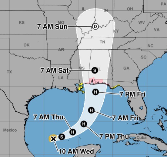
Isaias is forecast to reach hurricane strength on Thursday and remain a “dangerous hurricane when it makes landfall,” likely late Friday or Saturday along coastal Mississippi or Alabama, according to the National Hurricane Center.
The hurricane center’s forecast has the storm’s maximum winds peaking at 110 mph by 5 a.m. Friday, which would make it nearly a Category 3 hurricane, before moving inland by late Saturday afternoon.
A hurricane watch was issued Wednesday morning from Bay St. Louis, Mississippi to Indian Pass, Florida. A storm surge watch was in effect from the mouth of the Mississippi River to Yankeetown, Florida.
Isaias “will become the first hurricane of the 2026 season, the latest first hurricane to form in the Atlantic basin in over 100 years,” according to AccuWeather.
Isaias developed early Wednesday and was located 260 miles west-northwest of Progreso, Mexico, and 540 miles south-southwest of the mouth of the Mississippi River, according to the hurricane center’s 11 a.m. advisory. Its maximum sustained winds were at 45 mph as it moved east-northeast at 8 mph.
Isaias is expected to track east-northeast Thursday before making a turn to the northeast then north on Friday, according to forecasters. It likely will pass to the north of the Yucatan Peninsula on Thursday and approach the U.S. northern Gulf Coast on Friday.
Tracking map: Here’s the latest forecast path of likely Hurricane Isaias
National Hurricane Center forecasters expect it to peak in strength before reaching the coast. The stronger the storm becomes, the faster it will head in that direction, the advisory said. Forecasters also said the storm is likely to “grow significantly in size” once it reaches the northern Gulf Coast.
“It should be noted that there is significant uncertainty in where the system makes the northeast turn and how fast it moves toward the coast,” the hurricane center’s advisory said.
Gov. Ron DeSantis declared a state of emergency in 25 Florida counties throughout the Panhandle and Big Bend.
“Floridians should take this time to get disaster plans in place and ensure their hurricane supply kit is stocked,” DeSantis said.
Beginning on Friday and continuing through the weekend, 3 to 6 inches of rainfall is expected across the central U.S. Gulf Coast from southeastern Louisiana to the Florida Panhandle, with up to 10 inches possible in some areas. The National Hurricane Center forecasts between 2 to 4 inches of rainfall through Thursday along coastal areas of the Bay of Campeche with higher amounts possible in Campeche and western Yucatan.
AccuWeather on Tuesday estimated rain totals of up to 8 inches could drench a swath from Alabama to the Florida Panhandle, an area that has recently seen a lot of rain, increasing the potential for flooding. AccuWeather is calling for 8-12 inches of rain across southern Alabama and Mississippi.
There is also an increasing risk of strong winds and dangerous storm surge for areas of the northern Gulf Coast, the hurricane center said.
“Residents from Louisiana to the Florida Panhandle should closely monitor the latest forecast updates and ensure they have their hurricane plan in place,” the forecast said.
Hurricane season ends Nov. 30.
Copyright 2026 Sun Sentinel. All rights reserved. The use of any content on this website for the purpose of training artificial intelligence systems, algorithms, machine learning models, text and data mining, or similar use is strictly prohibited without explicit written consent.