Daily e-Edition
Evening e-Edition
Sign up for email newsletters
Sign up for email newsletters
Daily e-Edition
Evening e-Edition
Trending:
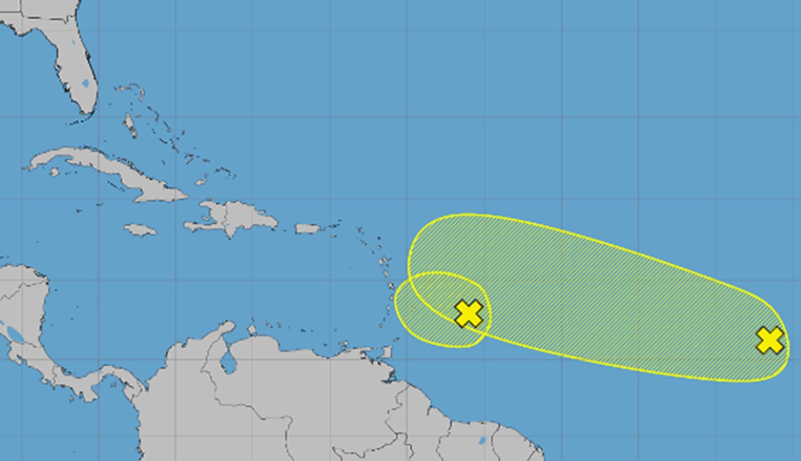
The National Hurricane Center on Friday continued to track two tropical waves in the Atlantic with a chance to become the season’s next tropical depression or storm, but development predictions have diminished since earlier forecasts.
As of the NHC’s 8 p.m. tropical outlook, the leading wave, Invest 92, was near the Caribbean’s Windward Islands with gusty winds and a large area of showers and thunderstorms.
“This system is moving into a region of increasing upper-level winds and drier air, and the potential for tropical cyclone formation has decreased,” forecasters said. “Even though development is highly unlikely, strong gusty winds to near gale force and areas of heavy rain are possible across portions of the Lesser Antilles tonight and on Saturday.”
The NHC dropped its chances to 10%, down from 20% Friday morning, that it would develop in the two to seven days. Earlier in the week, predictions had been up to 80%.
Chances are higher but reduced from earlier forecasts for a tropical wave, Invest 94, in the central tropical Atlantic located more than 1,000 miles west of the Cape Verde Islands with disorganized showers and thunderstorms.
“While environmental conditions are conducive for some development over the next few days, the system is expected to encounter strong upper-level winds next week, decreasing its chances for development,” forecasters said.
The NHC gives it a 30% chance to develop within the next two to seven days.
Some long-term computer models, such as the Global Forecast System, or GFS, have this system potentially approaching Florida after moving over or just north of Puerto Rico and Hispaniola.
If either system were to grow into a named system, it could become Tropical Storm Dolly.
The active tropics come near the 22nd anniversary of Hurricane Charley slamming into Florida, the beginning of one of the worst hurricane years in the state’s history.
So far the 2026 Atlantic hurricane season, which began June 1 and runs through Nov. 30, has been slow with only three named systems – tropical storms Arthur and Bertha and the short-lived Cristobal that spun up and fell apart this week.
After Dolly, the next name on the list is Edouard.
JUST IN: NOAA's Atlantic Hurricane Season Outlook remains 'below normal,' in August update
*U.S. residents need to remain prepared*
Details: https://t.co/kxshxyagwC#HurricaneOutlook @NWS @NWSCPC pic.twitter.com/3N9s8hrz8e
— NOAA (@NOAA) August 6, 2026
The National Oceanic and Atmospheric Administration earier this month updated its seasonal forecast stating it expects between seven and 13 named storms this year. Of those, two to six would become hurricanes. It also predicted that there might not be any major hurricanes this year, or at most two.
Already 2026 was forecast to have lower-than-average storm generation, and that has been reduced even further with the latest forecasts from the NOAA and other weather groups.
An average year would see 14 named storms and seven hurricanes, with three of those growing to Category 3 strength or higher.
The height of hurricane season is just beginning, though, running between mid-August and mid-October.
Copyright 2026 Orlando Sentinel. All rights reserved. The use of any content on this website for the purpose of training artificial intelligence systems, algorithms, machine learning models, text and data mining, or similar use is strictly prohibited without explicit written consent.